Belgian Antarctic Research Expedition 2005: a full report
Here is a nearly day by day report of the BELARE 2005 Logistics Survey Expedition that took place in November 2005 to further prepare the construction of the station.
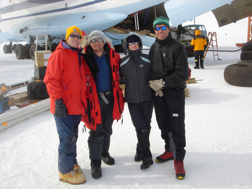
The team was composed of (from left to right): Frank Pattyn (ULB), Johan Berte (IPF), Maaike van Cauwenberghe (BELSPO) and Alain Hubert (IPF).
12-13 Nov. 2005
9h45 in the morning: the Antonov airplane takes fully loaded with all equipment and material (the payload was limited to 1000 kg for this flying distance). The tentative planning foresaw a direct flight to the Utsteinen site to drop off the goods at the base camp area, after which the air reconnaissance would start.
Unfortunately local white-out conditions at Utsteinen resulting in visibility close to 0 made it impossible to land safely. The decision was taken to fly back to the intermediate (emergency) fuel depot installed at 100 km West from Utsteinen.
The weather was good enough for a safe landing but, unfortunately, the airplane got stuck in a large sastrugi during taxiing. It took digging, pushing and pulling to free the airplane before refueling it. In the mean time the majority of the cargo was unloaded and secured on the ground.The airplane then took off for the air reconnaissance to the coast.
As planned, various areas of the coast were overflown but no landings were attempted. After the Breid Bay reconnaissance the pilots agreed to fly back to the Utsteinen site in the hope that the weather would have cleared up. The situation was indeed better and we could land. Unloading was done quickly and the airplane took off to collect the remaining of the equipment at the fuel depot while the team started hastily to build the base camp.
With weather getting worse again, this was a bit of a rush. It was now clear for the whole team that the Antonov would not return before a few days, leaving the base camp with a minimum of supplies. Late in the evening the airplane appeared unexpectedly above the base camp and landed in difficult conditions. The equipment was unloaded in an instant and the airplane disappeared again in the snow drift. The blizzard did not calm down before two nights and one day, forcing the team to remain inside the tents for most of the time.
14 Nov. 2005
First day of good weather, one of the priorities is to finish the base camp. The remainder of the equipment was recovered from the 2004 trench and tested if required. Frank and Johan were more than impatient to get the data from the Automatic Weather Station's backup system (Data Storage Unit). The DSU, being the back-up solution, contained hopefully an explanation for the abnormal data transmitted in August 2004. It turned out that the DSU did not function properly and had not collected one single data. This was only the beginning of a troublesome AWS refurbishment exercise ...
The good news is that the 2 Lynx Scandic IV snow scooters started without a glitch.
15 Nov. 2005
The base camp is more or less finished although the trench for storing the equipment during winter needs further enlargement, a task that will be carried out over the whole expedition.
We knew that the AWS had stopped transmitting data at the beginning of November. After further investigations, it turned out that the high-end lithium batteries were dead. They were about the only parts that were not covered by a back-up solution, given the high cost of the batteries and the large margin in their capacity. The supplier and the expedition's agent in Cape Town were called using the Iridium phone and said they would do everything they could to obtain a new set of batteries in the available timeframe.
The team continued to work on the faulty data logger It became clear that only a full reset and reprogramming could solve the problem, thereby destroying the last recorded data in the process. The team then installed the GSRP (GeoStatic Reference Point) using Leica GPS1200 differential GPS equipment.
To complement the original AWS setup, a second wind speed sensor was installed 4m above the ground and at 75m from the AWS itself in an area close to the building integration site. This sensor allows simultaneous wind speed measurements used to assess the wind-energy potential of the site and to define mechanical specifications for the building.
The first actions in the ice-measurements program were undertaken recording the accumulation/ablation dimensions on the ice stakes installed during the 2004 expedition. At the end of the day Alain climbed the second summit of the Utsteinen nunatak and returned with a harvest of magnificent photos and film recordings.
16 Nov. 2005
The AWS, now with reprogrammed data logger and recording DSU, is fully functional again. New tests revealed that the AWS data logger controller for some unknown reason switched from a 10 minutes transmitting interval to a 1 minute interval, generating much more transmissions than foreseen. As a result, the full battery capacity calculated for 2+ years was used in 11 months. New batteries are thus badly needed.
There is still quite a lot of wind which makes working on the hardware difficult. On the other hand, these windy conditions allowed to record snow-drift geometries over the ridge. The outside activities were completed with snow-clearing at the storage trench. New attempts to get a working Inmarsat data connection remained unsuccessful.
17 Nov. 2005
etting a new battery set on site using the evacuation flight is still an option but the lack of hard commitments makes the team work on a backup solution using the available batteries on site (6 in total).
In the mean time, work has started on the topographic measurements on the ridge. A reduced area of the ridge was selected to map. The area was divided using a 4m x 4m grid over a surface of approximately 800m². The news arrives that 2 new snow scooters planned to be flown in during the evacuation flight got stuck in Antwerp and won't be in Cape Town in time. They will remain at the Russian station to be used for the next expedition. The good news is that it is not needed to make the storage trench much bigger than it is now. 20 New ice stakes have been positioned on a line perpendicular to the ridge and will be used to measure ice movement as well as snow accumulation/ablation.
18 Nov. 2005
The new ice stakes have been positioned marked and measured with the D-GPS. Work on the topographic monitoring of the building area continuous. The grid has been mapped and an intensive photo survey is in progress. The new ice drill has been tested. This new tool can drill up to 6m depth and will be used to assess the snow/ice firmness close to the ridge. The area on the west side of the ridge will house the below-surface part of the building. It is important to assess the under-surface characteristics of the snow/ice in this area.
19 Nov. 2005
No wind and excellent conditions. Frank and Maaike start radar measurements in an area covering up to 500m on both sides of the ridge. They will then assist on the measurement of 3D surfaces using the D-GPS on the construction site. These radar measurements will combine with other survey methods to have a good view on the bedrock profile.
20 Nov. 2005
Sunday! In the context of the vicinity survey activities, a trip to one of the dry valleys in the mountains is planned. Access to this area is quite good, with only few crevasses. Arrived at the dry valley the team makes a short reconnaissance and Maaike collects a number of soil samples.
Alain took a little time off to climb the Wijderfjellet which is the highest peak of the Sor Rondane Mountains (3000m). It required crampons and an ice axe, but the effort was more than worthwhile, as from the top he had a 360° view far away to the plateau and to the ocean.
Late in the evening a status on the activities is made. A lot of time has been spent working on the AWS and Immarsat. The weather conditions at the time of the air survey made it impossible to follow the initial plan of having a team doing an over-land survey of the coast and access route to Utsteinen. Having a 2-man team doing this would compromise to much the on-going survey activities on site. A solution is found in the suggestion of Alain to do a solo-trip to the coast. Given Alain's broad experience the team decides to go along with this scenario.
On the flight in to Utsteinen, the Antonov overflew the route at low altitude, and Alain is reasonably confident that the terrain is free of crevasses. Alain will also make good use of the satellite images and maps that have been collected and prepared prior to the expedition.
21 Nov. 2005
The team prepares the over-land survey and packs the snow scooter and its sledge. Alain leaves for his solo trip to the coast and the rest of the team is carrying on with the topographic survey and ice measurements.
22 Nov. 2005
Official confirmation: no batteries on the evacuation flight ! The flight back to Novo by Antonov is expected to arrive on the 24th, depending on the wind conditions, and the evacuation back to Cape Town will be on the 25th, a few days earlier than expected.
Additional soil samples are taken to complete the "clean-state" sampling done in 2004. Maaike and Frank, trained bird-watchers, have taken a closer look at the snow petrel nests on the Utsteinen nunatak. They estimate that around 50 birds were present but could trace only a few nests.
Topographic measurements of the larger area are conducted.
23 Nov. 2005
Frank and Johan had to deploy a back up solution for the AWS batteries - using an amalgam of other batteries, shielded from the elements - to insure that data from the AWS continues to flow over the coming year.
Maaike concentrates on making an inventory of the on-site equipment while the last work on the trench is finished.
After an update on the satellite phone at 18h00 Alain reports he's at 50km from the base camp. Although there were problems with the sledge, he manages to arrive at the base camp late in the evening.
On its way to the coast, Alain stopped at the Japanese Asuka station for an hour to look around and see what changes were visible from his visit a year before. At the coast, he encountered some seals, mainly Weddel seals. There must have been two hundred individuals, mothers and pups sunbathing on the ice, next to openings through which they could slide into the ocean for a quick meal. The seals showed no indication of disturbance from Alain's presence.
24 Nov. 2005
At 9h30 satellite communication with Novo confirmed the airplane would take off and the team should prepare for the evacuation flight. The base camp is further dismantled and the equipment stored in the trench.
The AWS is checked and a final download is performed. Everything works but for how long ... that remains an open question ... . At 12h30 the Antonov arrives, a happy reunion with the crew. While the extra fuel drums brought in for the next season are unloaded, the airplane is refueled while the last bits of equipment disappear under-ground.
At 14h45 the Antonov takes off after taking the last group pictures. We fly over the site , remembering the time spent in this extraordinary place and thinking about the next expedition ...
25 Nov. 2005
Just another day at Novo, waiting for the flight to Cape Town. There is a lot of work to be done on the processing of the collected data. In the morning we are all invited to visit the Russian station. We will be taken there by the "Vector", an eight-wheeled vehicle that is being tested in Antarctica. In the Russian station the team made good use of the showers and the "banja", a Russian-type of sauna ... .
26 Nov. 2005
15h00: Take off for Cape Town !